Trail Smart: Your Tech Guide to Hiking Safety & Navigation
There’s nothing quite like the feeling of reaching a summit or discovering a hidden waterfall deep in the wilderness. But the very remoteness that makes hiking so rewarding also presents a major challenge: staying connected. Poor or non-existent cell service can turn a minor issue into a serious emergency. Fortunately, with the right technology and a little preparation, you can explore with confidence. This guide will show you how an eSIM and your smartphone can become your most essential pieces of hiking gear.
Ready to make your next adventure your safest yet? With Yoho Mobile’s flexible and affordable eSIM plans, you can get all your digital prep done before you even leave home. Get your adventure-ready eSIM today!
Before You Go: Preparing Your Digital Trail Kit
Proper preparation is the key to a safe and enjoyable hike. Long before you lace up your boots, your smartphone is the tool you need to set yourself up for success. This is where having a reliable data connection is non-negotiable.
Why an eSIM is Your Best Trail Companion
Imagine landing in a new country for a hiking trip, like trekking through the national parks of the USA or the highlands of Scotland. Instead of hunting for a physical SIM card, you can activate a data plan right from your phone. That’s the power of an eSIM. It allows you to download crucial information while you have a stable Wi-Fi or cellular connection.
With a Yoho Mobile eSIM, you can choose a plan that fits your trip’s duration and data needs perfectly, whether you’re exploring the Alps in Switzerland or the Rockies in the USA. This ensures you have the data you need to prepare, without overpaying for features you won’t use.
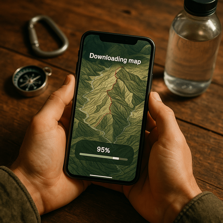
Downloading Offline Maps for Hiking
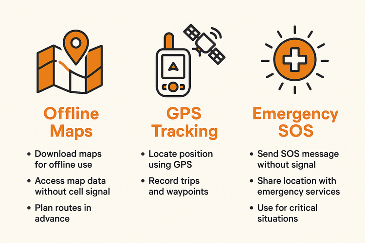
The single most important digital task before a remote hike is downloading offline maps. These are detailed topographical maps of your hiking area that are saved directly onto your device. Because they use your phone’s built-in GPS receiver, they work perfectly even without a cell signal.
- Choose an App: Use a reliable hiking app like AllTrails or Gaia GPS.
- Select Your Area: Find your planned trail and select the option to download the map for offline use.
- Download Everything: Don’t forget to download trail details, elevation profiles, and recent reviews or alerts. An eSIM makes it easy to download large map files without worrying about slow public Wi-Fi.
On the Trail: Leveraging Technology for Safety and Navigation
Once you’re on the trail, your phone transforms from a preparation tool into a lifeline for navigation and safety. Here’s how to make the most of it when you’re off the grid.
GPS Tracking Without a Signal
A common misconception is that you need cell service for your phone’s GPS to work. In reality, your smartphone has a dedicated GPS chip that communicates directly with satellites. As long as it has a clear view of the sky, it can pinpoint your location. Your pre-downloaded offline maps act as the visual interface, showing your exact location on the trail. This is the foundation of modern backcountry navigation and a critical tool for staying on course.
To ensure this works flawlessly, always check if your device is eSIM compatible and test your offline maps before you lose service.
Essential Mountain Safety Apps
Beyond navigation, your phone can host a suite of apps designed for mountain safety. Many of these apps have crucial offline functions. Consider downloading:
- First Aid App: The Red Cross First Aid app provides step-by-step instructions for common injuries, all available offline.
- Location Sharing/Safety App: Apps like Cairn allow you to share your real-time location and trip itinerary with trusted contacts. It can even show you spots on your route where other users have found cell service.
- Weather App with Offline Forecasts: Some weather apps can download a forecast for the next 24-48 hours, giving you a vital heads-up on changing conditions.
Staying Connected When It Matters Most
While planning for zero connectivity is smart, knowing how to maximize your chances of finding a signal for an emergency call or a check-in text provides invaluable peace of mind.
Maximizing Connectivity with an eSIM
In areas with spotty coverage, an eSIM can be a significant advantage. Unlike a physical SIM that is locked to one provider, Yoho Mobile’s eSIMs can often connect to multiple local network partners. This means your phone automatically searches for the strongest available signal, increasing your chances of getting a connection on a high ridge or in a clearing.
Even better, you never have to worry about being completely cut off. With Yoho Care, even if your main data package runs out, we provide a backup connection to ensure you can send an emergency message or check your location. It’s the ultimate safety net for any adventurer. Learn more about the peace of mind offered by Yoho Care.
Frequently Asked Questions (FAQ)
Can I use an eSIM if my phone has no signal?
You need a signal to activate the eSIM and download your maps and apps initially. However, once everything is downloaded, features like offline maps and GPS tracking are designed specifically to work without any cell signal. That’s why preparation is so important.
How much data do I need for a hiking trip?
Data needs vary, but a 3-5 GB plan is often sufficient for a week-long trip. This gives you plenty of data to download maps, check weather forecasts, and use apps before your hike, with some left over for use when you find a signal. Check our travel data usage calculator to get a better estimate.
What’s the best eSIM for hiking in Europe?
For multi-country treks, like the Tour du Mont Blanc, a regional eSIM is ideal. Yoho Mobile offers comprehensive Europe eSIM plans that cover dozens of countries with a single installation, so you can cross borders without ever losing connectivity.
Do mountain safety apps work without internet?
Many key features do. GPS tracking, offline first aid information, and pre-downloaded weather forecasts work without a connection. However, features that require sending information, like live location sharing, will only update when you momentarily find a signal.
Conclusion
Venturing into the great outdoors no longer means leaving safety and certainty behind. By integrating an eSIM into your hiking preparations, you empower your smartphone to be a powerful tool for navigation, safety, and emergency communication. From downloading detailed offline maps in your hotel room to having a better chance of finding a signal on a remote peak, technology is here to enhance your adventure, not detract from it.
Ready to hike smarter and safer? Don’t leave your connectivity to chance. Try Yoho Mobile with a free eSIM trial and experience seamless connection on your next adventure.
VIŠE PAŽLJIVO ODABRANIH SAVETA ZA PUTOVANJA
Zion National Park in One Day
Pročitajte višeTutorialsHow Much Data Does Google Maps Use? + Tips to Save Data
Pročitajte višeTravel GuideseSIM for USA National Parks: Connectivity Guide (2025)
Pročitajte višeTravel Tips16 Travel Gadgets That Make a Difference (Tested & Recommended)
Pročitajte više