Tehnološki vodnik za pohodništvo 2025: Ostanite varni z GPS-om, zemljevidi brez povezave in aplikacijami
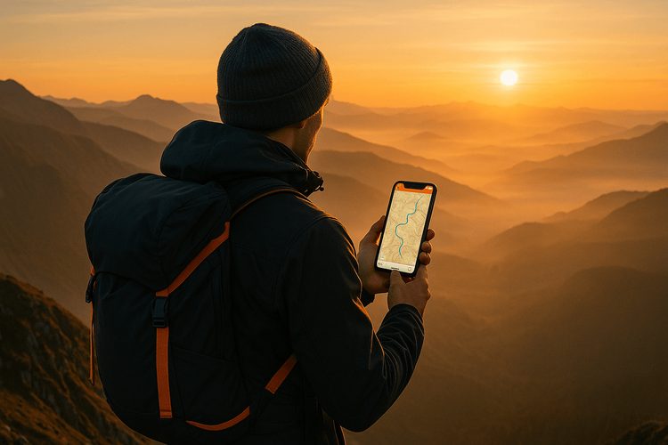
Klic gora je neustavljiv – svež zrak, osupljivi razgledi in občutek dosežka po zahtevnem pohodu. Toda v divjini je priprava vse. Čeprav je cilj pobegniti od vsega, je izguba poti ali nezmožnost klica na pomoč tveganje, ki si ga nihče ne bi smel privoščiti. Na srečo je pametni telefon v vašem žepu močno orodje za varnost in navigacijo, tudi ko ste kilometre stran od najbližjega mobilnega signala.
Ta vodnik vas bo popeljal skozi uporabo zemljevidov brez povezave, GPS-a in bistvenih varnostnih aplikacij, da bo vaš naslednji pohod varnejši. Obravnavali bomo tudi, kako je lahko zanesljiva podatkovna povezava, kot jo ponuja Yoho Mobile, vaša rešilna bilka, ko jo najbolj potrebujete. Preden sploh spakirate gojzarje, zakaj ne bi spakirali še mirne vesti? Pridobite brezplačen preizkus eSIM, da preizkusite svojo povezljivost doma.
Obvladajte svojo pot z navigacijo brez povezave
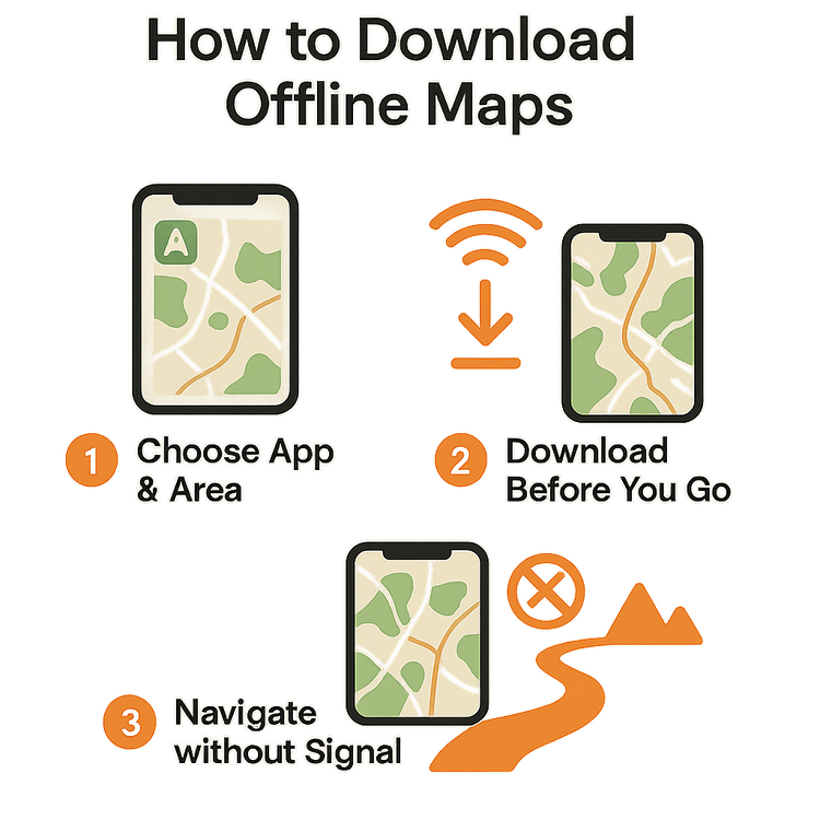
Vaš največji strah na oddaljeni poti ne bi smel biti napačen zavoj. Mobilni signal je v goratih ali gosto gozdnatih območjih znano nezanesljiv, zato so zemljevidi brez povezave nepogrešljivi za vsakega resnega pohodnika. To so zemljevidi, ki jih pred potovanjem prenesete na svoj telefon, kar vam omogoča, da vidite svojo lokacijo in navigirate po poteh z uporabo GPS-a v telefonu, ne da bi potrebovali internetno povezavo.
Kako začeti:
- Izberite aplikacijo: Priljubljene pohodniške aplikacije, kot sta AllTrails ali Gaia GPS, so odlična izbira. Mnoge ponujajo brezplačne različice z osnovnimi zmožnostmi zemljevidov brez povezave, medtem ko plačljive naročnine odklenejo podrobnejše topografske plasti.
- Prenesite svoje zemljevide: Ko ste doma povezani na Wi-Fi, odprite izbrano aplikacijo. Poiščite pot ali regijo, kjer boste hodili – na primer priljubljene poti v nacionalnih parkih ZDA – in poiščite možnost za prenos zemljevida za uporabo brez povezave.
- Preizkusite: Preden odidete, preklopite telefon v letalski način in odprite aplikacijo. Morali bi videti podroben zemljevid in svojo trenutno lokacijo na njem. Ta preprosta priprava je ena najboljših stvari, ki jih lahko naredite za svojo varnost.
Moč GPS-a za varnost pri pohodništvu
Pogosto je napačno prepričanje, da GPS v telefonu preneha delovati brez mobilnega signala. V resnici ima večina sodobnih pametnih telefonov namenski čip GPS, ki komunicira neposredno s sateliti, neodvisno od vašega mobilnega omrežja. To pomeni, da dokler ima vaš telefon baterijo in jasen pogled na nebo, lahko določi vašo lokacijo.
To je ključnega pomena za varnost pri pohodništvu. Ko uporabljate aplikacijo z zemljevidi brez povezave, bo GPS vašega telefona prikazal vaš natančen položaj kot modro piko na predhodno prenesenem zemljevidu poti. Spremljate lahko svoj napredek, se prepričate, da ste na pravi poti, in vidite, koliko poti je še pred vami. V nujnih primerih lahko z aplikacijo GPS poiščete svoje natančne koordinate zemljepisne širine in dolžine ter jih delite z reševalnimi službami – informacija, ki vam lahko reši življenje.
Bistvene aplikacije za varnost v gorah, ki jih ne smete spregledati
Poleg navigacije lahko na svojem telefonu gostite vrsto aplikacij, zasnovanih za varnost v gorah. Tukaj je nekaj vrst, ki jih je vredno prenesti pred potovanjem:
- Prva pomoč: Aplikacije, kot je St John Ambulance First Aid, ponujajo preprosta navodila po korakih za ravnanje z običajnimi poškodbami, od žuljev do zvinov. Kot bi imeli priročnik za prvo pomoč v žepu.
- Vreme: Nenadna sprememba vremena lahko prijeten pohod spremeni v nevarno situacijo. Aplikacije, kot sta AccuWeather ali Carrot Weather, lahko zagotovijo podrobne napovedi in opozorila o hudem vremenu. Preverite jih tik preden izgubite signal.
- Zasilni oddajniki: Aplikacije, kot je what3words, so revolucionirale deljenje lokacije v sili. Aplikacija deli svet na 3-metrske kvadrate in vsakemu dodeli edinstven naslov iz treh besed. V nujnih primerih lahko te tri besede posredujete reševalcem, da natančno določijo vašo lokacijo.
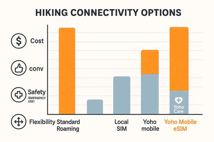
Te aplikacije so zmogljive, vendar za deljenje informacij ali prejemanje opozoril v realnem času potrebujete podatkovno povezavo. Tu postane prilagodljiva potovalna eSIM kartica neprecenljiva. Sestavite si načrt po meri z Yoho Mobile za svojo naslednjo pustolovščino, da boste plačali samo za podatke, ki jih potrebujete.
Ostanite povezani: Vaša rešilna bilka, ko je to najpomembneje
Tudi z najboljšo pripravo pridejo trenutki, ko se morate povezati. Morda najdete košček signala na visokem grebenu in želite družini poslati hitro sporočilo “Na varnem sem”, preveriti nujno vremensko napoved ali poklicati na pomoč. Zanašanje na drago in nepredvidljivo gostovanje vašega domačega operaterja ni idealno.
To je popoln scenarij za eSIM. Yoho Mobile eSIM omogoča vašemu telefonu, da se poveže z lokalnimi omrežji, kadar koli je signal na voljo, in pogosto zagotavlja boljšo pokritost kot vaš domači ponudnik. Ne glede na to, ali se odpravljate v švicarske Alpe ali raziskujete poti na Japonskem, imate lahko na dosegu roke ugodne in zanesljive podatke.
Še bolje, zaščiteni ste z Yoho Care. Če se vam zgodi, da porabite svoj podatkovni paket, Yoho Care zagotavlja varnostno mrežo osnovne povezljivosti, ki vam omogoča, da še vedno pošiljate nujna sporočila ali dostopate do storitev za klice v sili. Nikoli niste popolnoma odrezani. Pred potovanjem se prepričajte, da je vaš telefon pripravljen na eSIM, tako da preverite naš seznam združljivosti.
Pogosto zastavljena vprašanja (FAQ)
Kakšna je razlika med GPS-om in mobilnimi podatki za pohodništvo?
GPS (Global Positioning System) uporablja satelitske signale za določanje vaše lokacije in ne potrebuje internetne ali mobilne povezave. Mobilni podatki uporabljajo vaše mobilno omrežje za dostop do interneta za prenos zemljevidov v realnem času, preverjanje vremena ali komuniciranje. Pri pohodništvu uporabljate GPS s predhodno prenesenimi zemljevidi brez povezave, ko nimate signala.
Ali lahko svoj telefon uporabim kot zasilni oddajnik brez signala?
Nekateri namenski satelitski komunikatorji (kot je Garmin inReach) lahko pošljejo SOS signal brez mobilnega signala. Vendar pa večina aplikacij za zasilne oddajnike na pametnem telefonu potrebuje mobilni ali Wi-Fi signal za pošiljanje sporočila. Strategija je, da s svojim GPS-om pridobite koordinate in nato poiščete mesto z delčkom signala, da jih pošljete.
Koliko podatkov potrebujem za pohodniški izlet z eSIM?
Če ste predhodno prenesli zemljevide, bo vaša poraba podatkov na poti minimalna. Majhen podatkovni paket (npr. 1-3 GB) običajno zadostuje za enotedensko potovanje za občasna javljanja, posodobitve vremena in uporabo v sili. Prilagodljivi paketi Yoho Mobile vam omogočajo, da izberete pravo količino za svoje potrebe.
Ali bo Yoho Mobile eSIM deloval v oddaljenih nacionalnih parkih, kot sta Yellowstone ali Banff?
Pokritost v obsežnih nacionalnih parkih je lahko za vse operaterje nezanesljiva. Vendar se Yoho Mobile eSIM poveže z najboljšimi razpoložljivimi lokalnimi omrežji. To pogosto pomeni, da boste našli signal na območjih okoli centrov za obiskovalce, priljubljenih izhodišč in na višje ležečih točkah, kjer vaš domači ponudnik morda nima pogodbe o gostovanju. To poveča vaše možnosti za vzpostavitev povezave.
Zaključek
Odpraviti se v naravo ne pomeni, da pustite varnost za seboj. Z izkoriščanjem moči sodobne tehnologije v vašem žepu lahko samozavestno navigirate, se pripravite na nujne primere in ostanete povezani, ko je to pomembno. Predhodno nalaganje zemljevidov brez povezave, razumevanje uporabe GPS-a v telefonu in opremljanje z bistvenimi varnostnimi aplikacijami so temeljni koraki za vsakega pohodnika.
Združevanje te priprave z zanesljivo rešitvijo za povezljivost podjetja Yoho Mobile zagotavlja, da imate rešilno bilko do zunanjega sveta. S prilagodljivimi paketi in mirnostjo, ki jo prinaša Yoho Care, se lahko osredotočite na lepoto poti pred vami.
Ste pripravljeni na pametnejše in varnejše pohodništvo? Raziščite prilagodljive pakete eSIM Yoho Mobile in ostanite povezani na svoji naslednji pustolovščini.