Alps Mountain Safety Guide: Essential Apps & Data Connectivity
The Swiss Alps are a breathtaking spectacle of nature’s grandeur, offering pristine trails, panoramic vistas, and unforgettable adventures. But beneath this beauty lies an environment where conditions can change in an instant. In these majestic mountains, your most crucial piece of safety equipment might not be your hiking boots or your waterproof jacket—it’s your smartphone, powered by a reliable data connection.
Imagine being lost as fog rolls in, needing an urgent weather update, or facing an emergency where every second counts. In these moments, a stable connection is not a luxury; it’s a lifeline. Before you set foot on the trail, ensuring you have dependable data is the first step to a safe adventure. With a solution like a Yoho Mobile eSIM for Switzerland, you can guarantee you’re prepared for whatever the mountains throw at you.
Picture by ShaoChen Yang on Unsplash
Why a Data Connection is Your Most Important Hiking Gear
In the past, mountain safety meant a physical map and a compass. Today, technology has revolutionized how we explore the outdoors, but it hinges on one critical component: connectivity. A stable data connection transforms your phone from a simple camera into a powerful safety hub.
It’s the invisible thread that links you to real-time weather forecasts, preventing you from being caught in a sudden storm. It’s the digital compass that provides live GPS tracking on detailed topographic maps, ensuring you stay on the right path. Most importantly, it’s your direct line to emergency services, allowing you to transmit your precise location for a swift rescue. Without data, these life-saving tools are rendered powerless, turning your advanced smartphone into little more than a dead weight.
Essential Apps for Your Alpine Adventure (And Why They Need Data)
Having the right applications on your phone is vital, but they are only effective if they can access the internet. Here are the must-have apps for any hike in the Swiss Alps.
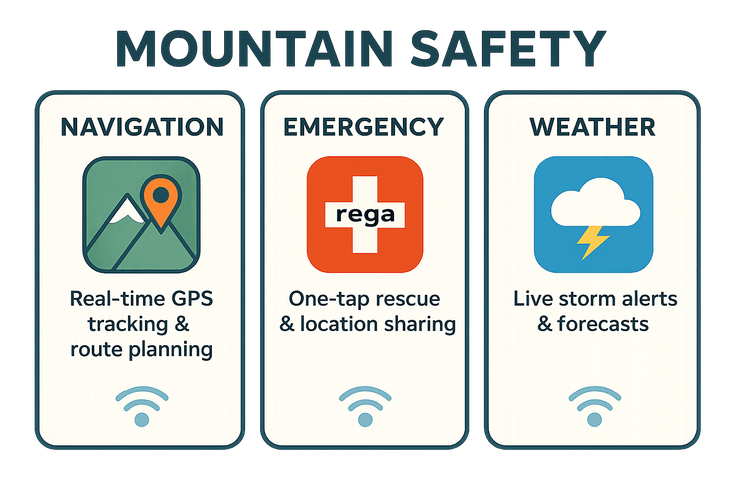
Navigation & Mapping Apps
While downloading offline maps is a great preparatory step, it’s the online features that make apps like SwissTopo, Komoot, or AllTrails truly powerful. A live data connection allows for on-the-fly route adjustments, searching for nearby huts or water sources, and sharing your real-time location with family back home. Comparing offline maps vs. online maps for mountain safety reveals a clear winner: a combination of both, powered by a steady data stream.
Emergency & Rescue Apps
This is where a data connection becomes non-negotiable. The Rega App, operated by Switzerland’s primary air rescue service, is a must-install. With a single tap, the app alerts the emergency services and automatically transmits your exact GPS coordinates. This simple action, which requires a data signal, can drastically reduce rescue times and save lives. The importance of data for Swiss rescue services cannot be overstated—it’s the backbone of modern mountain rescue operations.
Weather & Avalanche Warning Apps
The Alpine weather is notoriously unpredictable. Apps like MeteoSwiss and White Risk (for winter tours) provide live radar, storm warnings, and avalanche bulletin updates. Receiving a push notification about an incoming thunderstorm or changing avalanche conditions is critical information that you can only get with an active data connection, allowing you to make informed decisions to turn back or seek shelter.
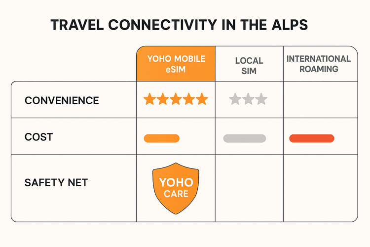
Choosing the Right Connectivity Solution for the Swiss Alps
For a trip to Zermatt or the Jungfrau region, relying on expensive and often unreliable international roaming is a gamble you can’t afford to take. Hunting for a physical local SIM card upon arrival eats into your adventure time. The smartest solution is a travel eSIM.
An eSIM (embedded SIM) from Yoho Mobile allows you to download a data plan directly to your phone before you even leave home. You land in Switzerland, turn on your eSIM line, and you’re instantly connected. Check if your phone is compatible on our eSIM compatible devices list.
What truly sets Yoho Mobile apart for mountain adventurers is the peace of mind offered by Yoho Care. Even if you exhaust your high-speed data allowance mid-hike, Yoho Care ensures you’re not cut off. It provides a continued, basic-speed connection sufficient for critical tasks like sending your location via WhatsApp or using the Rega emergency app. This safety net is invaluable in the backcountry.
Practical Tips for Staying Connected & Safe
- Conserve Your Battery: Your connection is useless if your phone is dead. Lower screen brightness, enable low power mode, and close apps running in the background.
- Carry a Power Bank: This is a non-negotiable piece of gear. A fully charged portable power bank can recharge your phone multiple times, ensuring you have power when you need it most.
- Download Offline Maps: Always download your planned route for offline use before you start. Consider this your primary backup.
- Inform Someone: Always leave your detailed itinerary with someone you trust and agree on check-in times.
Frequently Asked Questions (FAQ)
Do I really need a data plan if I have offline maps?
Yes. While offline maps are essential for basic navigation, they don’t provide real-time weather alerts, allow you to use one-tap emergency apps like Rega, or let you share your live location. A data plan is your connection to live, critical safety information.
What is the best emergency app for hiking in the Swiss Alps?
The official Rega app is widely considered the best and most essential. It connects you directly to the Swiss air rescue service and automatically sends your precise coordinates, which is crucial for a fast and accurate rescue operation.
How much data do I need for a hiking trip in Zermatt?
For a week-long trip focused on hiking, a plan with 3-5 GB is usually sufficient for navigation, weather checks, and occasional social media use. Yoho Mobile offers flexible eSIM plans for Switzerland that you can tailor to your trip’s length and data needs.
Will an eSIM work in remote mountain areas in Switzerland?
Yoho Mobile partners with top-tier local network providers in Switzerland to offer the best possible coverage, even in mountainous regions. While no carrier can guarantee 100% coverage on every peak and in every valley, our network is designed to keep you connected across the vast majority of popular hiking trails.
Conclusion: Your Safety is Worth the Connection
Hiking in the Swiss Alps is an experience of a lifetime, but preparation is the key to ensuring it remains a positive one. In today’s connected world, reliable data is as fundamental to mountain safety as a good pair of boots. It powers the tools that guide you, inform you, and connect you to help when you need it most.
By choosing a Yoho Mobile eSIM, you’re not just buying data; you’re investing in a seamless, reliable, and safe adventure. With the added security of Yoho Care, you can explore with the confidence that you’re never truly alone. Don’t leave your safety to chance. Get your Yoho Mobile Switzerland eSIM today and explore the Alps with confidence.
Lisää kuratoituja matkavinkkejä
Where to Go in Switzerland for the First Time: A 10-Day Itinerary You’ll Love
Lue lisääTravel GuideseSIM for Switzerland: Stay Connected on Trains & Alps | Yoho Mobile
Lue lisääTravel TipseSIM for Hiking: Your Guide to Mountain Navigation & Safety
Lue lisääTravel TipsTravel Safety in Bangkok: Why a Reliable eSIM is Crucial
Lue lisää