A Hiker's Tech Guide to Navigation & Safety | Yoho Mobile
There’s nothing quite like the feeling of reaching a summit in the Italian Dolomites or trekking a remote path in the Spanish Pyrenees. The fresh air, the stunning vistas, the quiet solitude—it’s what draws us to the mountains. But with that beauty comes the inherent risk of getting lost, injured, or disconnected when you need help the most. Fortunately, the most powerful tool for modern hiking might already be in your pocket. Your smartphone, when used correctly, can be your navigator, your safety beacon, and your lifeline.
But how do you ensure this tool works when you’re miles from the nearest cell tower? This guide, written from one hiker to another, will show you how to leverage technology for navigation and safety, and why a reliable data connection is a non-negotiable part of your gear. Before you even pack your bags, make sure you have the right connectivity. Explore flexible data plans for your next adventure and hike with confidence.
Gearing Up: Essential Hiking Tech Beyond Boots and a Backpack
While your boots, backpack, and water bottle are fundamental, your digital gear is just as crucial. A portable power bank is a must-have to keep your devices charged, and a waterproof case can save your phone from an unexpected downpour.
However, the real game-changer is how you prepare your phone for the trail. It’s not just about having a device; it’s about equipping it with the right apps, maps, and, most importantly, a dependable connection strategy. This guide breaks it down into three core pillars: Navigation, Safety, and Connectivity.
Mastering the Trail: Navigation With and Without a Signal
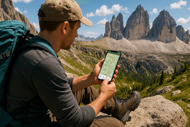
Long gone are the days of relying solely on a paper map and compass (though you should still carry them as a backup!). Today’s offline navigation apps offer unparalleled detail and ease of use.
The Power of Offline Navigation Apps
The biggest mistake a hiker can make is assuming they’ll have a cell signal. That’s where offline maps come in. Apps like AllTrails, Gaia GPS, and Komoot allow you to download detailed topographic maps of your entire hiking area directly to your phone. Before you leave your Wi-Fi zone, simply download the region you’ll be exploring. Your phone’s built-in GPS works independently of a cellular signal, meaning it can pinpoint your location on that downloaded map, keeping you on track even in the deepest valleys.
Conserving Battery While Using GPS
GPS is a notorious battery hog. To ensure your phone lasts the entire trek, follow these battery conservation tips:
- Go into Airplane Mode: This is the most effective tip. Since your GPS works without a cell signal, you can turn off cellular and Wi-Fi radios to save massive amounts of power.
- Lower Screen Brightness: Your screen is the biggest power consumer. Keep it dim and only turn it on when you need to check your position.
- Close Background Apps: Ensure no other apps are running in the background, consuming precious battery life.
- Keep it Warm: In cold weather, batteries drain faster. Keep your phone in an inside pocket close to your body.
Safety First: Your Phone as a Lifesaving Device
Beyond navigation, your phone is a critical piece of safety equipment. From checking last-minute weather reports to calling for help, its utility in an emergency is priceless—but only if it can connect.
Emergency Communication: Why Data is Your Lifeline
An ‘SOS’ or ‘No Service’ message on your screen can be terrifying in an emergency. However, you don’t always need full bars to communicate. Even a fleeting, weak data signal can be enough to send a text message through an app like WhatsApp, share your GPS coordinates, or load a simplified weather radar. This is where having the right mobile data plan becomes a matter of safety, not just convenience.
This is why an eSIM for hiking is such a game-changer. An eSIM (or embedded SIM) allows your phone to connect to local networks without needing a physical SIM card. When you’re hiking in a place like the Pyrenees, which straddles both Spain and France, an eSIM can seamlessly switch between the best available carriers, maximizing your chances of finding a signal.
Furthermore, Yoho Mobile offers an incredible safety net with Yoho Care. Even if you manage to use all your high-speed data, Yoho Care ensures you’re never completely cut off. It provides a basic, low-speed connection perfect for sending an emergency text or location pin. That’s peace of mind you can’t put a price on.
Choosing the Right Connectivity for the Trail
When it comes to staying connected abroad, you have a few options. Here’s how they stack up for a hiker.
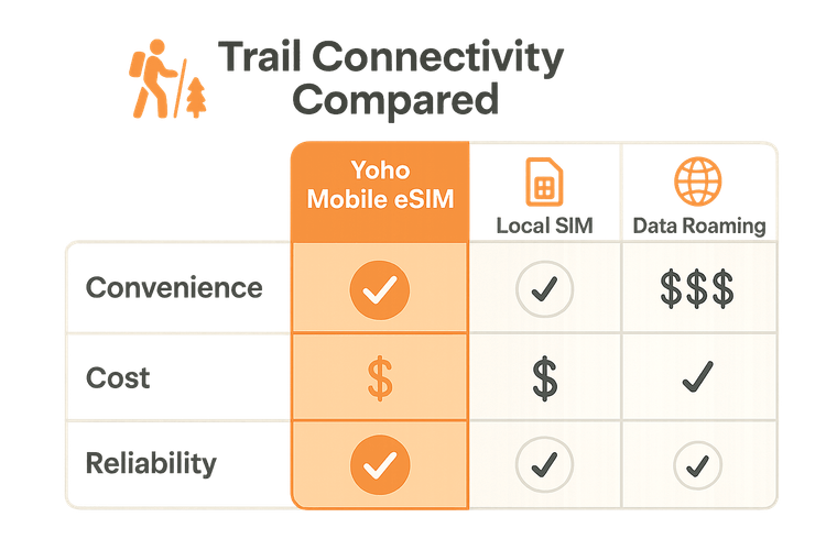
| Feature | Yoho Mobile eSIM | Local SIM Card | Home Carrier Roaming |
|---|---|---|---|
| Convenience | Excellent | Poor | Good |
| Cost | Excellent | Good | Poor |
| Flexibility | Excellent | Fair | Fair |
| Activation | Instant (Digital) | Requires Store Visit | Automatic |
As you can see, an eSIM provides the ultimate blend of convenience and affordability. There’s no need to find a store upon arrival or fumble with tiny plastic cards with cold fingers on the trail. With Yoho Mobile, you can purchase and install your plan before you even leave home. For iOS users, the process is even simpler: after purchase, just tap ‘Install’ to begin the seamless, 1-minute setup—no QR codes needed. Just make sure to check if your device is eSIM compatible beforehand.
Frequently Asked Questions (FAQ)
What’s the best way to stay connected while hiking in the mountains?
An eSIM is the most reliable and convenient option. It allows you to connect to the best local networks without needing a physical SIM card. Paired with a power bank and offline navigation apps, an eSIM ensures you have a comprehensive tech toolkit for both navigation and emergency communication for hikers.
Can I use an eSIM for hiking if I’m going to a remote area?
Absolutely. An eSIM connects to the same towers as local SIM cards. Its advantage is the ability to switch between networks in some regions, increasing your chances of finding a signal where a single carrier might not have coverage. For extreme remote areas with no service, a dedicated satellite messenger is recommended, but an eSIM is the best cellular-based solution.
Are offline navigation apps for hiking free?
Many of the best apps for trails, like AllTrails, offer robust free versions that include trail tracking and maps. However, the crucial feature of downloading maps for offline use typically requires a paid subscription, which is a small but highly recommended investment for any serious hiker.
How much data do I need for a hiking trip?
Data usage for hiking is generally low if you’ve pre-downloaded your maps. You’ll mainly use data for checking weather forecasts, sending messages, or light browsing. A plan with 1-3 GB for a week-long trip is usually sufficient. Yoho Mobile’s flexible plans let you choose exactly what you need.
Conclusion: Hike Smarter, Not Harder
The mountains call for respect and preparation. By embracing modern hiking safety tech, you’re not diminishing the adventure; you’re enhancing it with a layer of security. Your smartphone, equipped with offline maps and a reliable Yoho Mobile eSIM, transforms from a daily device into an indispensable trail companion. It’s the smart way to explore, ensuring you can focus on the beauty around you, confident that you’re prepared for whatever lies ahead.
Ready to equip yourself with the best connectivity for your next trail? Try a free eSIM from Yoho Mobile and experience the peace of mind that comes with staying connected, wherever your boots may take you.
نکات سفر منتخب بیشتر
Tech Guide for Adventure Travel: Stay Connected Off-Grid with an eSIM
بیشتر بخوانیدTravel TipseSIM for Hiking: Your Guide to Mountain Navigation & Safety
بیشتر بخوانیدTravel Tips12 Essential Travel Apps to Enhance Your Journey in Europe
بیشتر بخوانیدTutorialsHow Much Data Does Google Maps Use? + Tips to Save Data
بیشتر بخوانید